Land Judging in Oklahoma
James H. Stiegler, Extension Soils Specialist
Department of Plant and Soil Sciences
Introduction
Soil is a basic natural resource used by humans to meet one or more
of their needs. It provides raw materials, stores water and nutrients,
and supports growing plants that produce food and fiber. It also provides
space for cities, highways, recreation, and wildlife. Nothing surrounds
us more in our daily lives. But, like so many things important to life,
soil goes unnoticed until we learn to appreciate it.
The land resource is limited in quantity and its quality. It varies
from place to place as a result of the interactions of climate and vegetation
on geological materials as conditioned by topography over a period of time.
Even small changes in any one of the soil forming factors can create a
different soil. It is no wonder that so many kinds of soils exist with
different profile features and properties. Soils vary in the kind, number,
and degree of development of major horizons and sub-horizons that may form.
Few soils have all horizons, but all soils exhibit some of them.
Judging Land
Land judging is a recently added judging event in the field of agriculture.
Land can be judged much like animals or crops. In judging crops, we look
at the size, shape, and quality and determine which is the best. Similarly,
when judging land, we look for clues that tell us how well the land can
produce crops or be used for other purposes. Soil characteristics, climate,
and topography are good clues to the soil's capabilities, but close examination
of the soil texture, structure, depth, permeability, reaction, degree of
erosion, slope, drainage, and flooding potential are necessary to classify
land into capability classes. In land judging, the major factors affecting
how the land can be used must be determined. These factors are used to
correctly recommend conservation practices and fertilizers for conserving
soil.
Land judging can help to:
Soil Profile
The term "soil profile" is an important concept to learn. Soil profile
is a side view or vertical cross-section of the soil as seen in a ditch
bank or dug pit that allows the topsoil and subsoil to be examined. When
we look beneath the surface of the soil, we see that the soil is divided
into layers or "horizons." These layers differ in color, physical properties,
chemical composition, and biological characteristics. This is the soil
profile. It has three major parts or horizons: (1) the topsoil or "A" horizon,
(2) the subsoil or "B" horizon, (3) the parent material or "C" horizon.
A hypothetical soil profile is shown in Figure 1. Most land judging decisions
are based on a soil profile that is at least 40 inches deep.
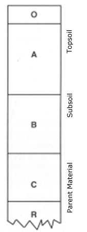 |
Organic horizon of undecomposed and decomposed
organic matter. Absent in cultivated and many other soils.
Mineral surface soil which has accumulated decomposed organic
matter and is usually darker colored than lower layers. It is also the
horizon that has lost organic matter, clay, iron, and aluminum due to downward
movement.
Mineral horizon that usually has a finer texture, or a darker,
stronger, redder color and a distinctly different developed structure.
Structure is often more distinct than in the "A" horizon.
Mineral horizon of weathered parent material like the material
from which the soil developed or other substratum of unconsolidated material
not related to the above soil.
Underlying consolidated bedrock. Absent under many soils. |
Figure 1. Hypothetical soil profile showing the letter designation used
in describing the major kinds of horizons usually present.

Soil Factors
Texture
Soil texture refers to the relative proportion of sand, silt, and clay
particles in a specific soil mass. It is easiest to determine when the
soil is moist. Sand feels gritty when rubbed by the finger. Silt feels
slick or velvety. Clay is usually sticky and plastic when wet and when
pinched between the thumb and finger forms a flexible ribbon.
The surface texture is normally determined from at least
plow depth or 6 inches, however, erosion may have removed the surface to
such an extent that only 1 or 2 inches may remain. For contests, a boxed
sample of surface soil and subsoil will be provided to judge texture.
In soils, several subdivisions of texture are recognized and are illustrated
below. For land judging we recognize five texture categories represented
by the middle column of the accompanying table.
Texture Groups
| Sandy Soils |
Coarse |
Sand
|
| |
|
Loamy sand
|
| Loamy Soils |
Moderately coarse |
Sandy loam
|
| |
|
Fine sandy loam
|
|
Medium |
Very fine sandy loam
|
| |
|
Loam
|
| |
|
Silt loam
|
| |
|
Silt
|
|
Moderately fine |
Clay loam
|
| |
|
Sandy clay loam |
| |
|
Silty clay loam |
| Clay Soils |
Fine |
Sandy clay
|
| |
|
Silty clay
|
| |
|
Clay
|
Coarse-textured soils are loose, very friable, and the
individual grains can be readily seen or felt. When squeezed between thumb
and forefinger, it feels gritty and will not ribbon or stain fingers. Squeezed
when dry, it will fall apart as pressure is released. When moist, a mold
may be formed which is unstable and crumbles as the soil is handled.
Moderately coarse-textured soils feel gritty but contain
enough silt and clay to make moist soil hold together. The individual sand
grains can readily be seen and felt. Squeezed when dry, it will form a
mold which breaks readily upon handling. If squeezed when moist, a mold
can be formed which can be carefully handled without breaking. It forms
no ribbon or very poor ribbon.
Medium-textured soils have a slightly smooth or velvety
feel when moist. Squeezed when dry, it forms a mold that will bear careful
handling. The mold formed by squeezing when moist can be handled freely,
without breaking. When the moistened soil is squeezed out between thumb
and forefinger, it will form a poor ribbon with a dull surface.
Moderately fine-textured soils usually break into clods
or lumps when dry. When the moist soil is squeezed out between thumb and
forefinger, it crushes with some effort. It will form a short (1 inch to
2 inch) well-formed ribbon with a shiny surface which will tend to break
or the ribbon will bend downward. The sandy clay loam texture has a slightly
gritty feel when moist.
Fine-textured soils form very hard, massive lumps or clods
when dry and are quite plastic and sticky when wet. When the moist soil
is squeezed out between thumb and forefinger it crushes with considerable
effort and will form a long (2 inch+) ribbon which will support itself.
The sandy clay texture may also have a slightly gritty feel when moist.

Soil Depth
Depth refers to the total thickness of the surface and subsoil plus
any underlying material that is favorable for root development. Soils are
categorized into several different soil depths. Depth is an important factor
of soils. It determines the total amount of water held in the soil, the
volume of soil available for plant root growth, and the supply of nutrients
available to plants. Generally this material is underlain by bedrock, clay,
or shale beds, or alluvial material.
Deep soils have over 40 inches of soil that can be penetrated
by plant roots.
Moderately deep soils have over 20 inches of soil but
less than 40 inches of soil that can be penetrated by plant roots.
Shallow soils have over 10 inches but less than 20 inches
of soil that can be penetrated by plant roots.
Very shallow soils have less than 10 inches of soil that
can be penetrated by plant roots.
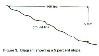
Soil Slope
Slope has a tremendous effect on water runoff, erosion, and use of
farm machinery. It is expressed as a percent, and is defined as the number
of feet that the land rises or falls in a 100-foot horizontal distance.
For example, a slope between two points which are 100 feet apart with a
difference in elevation of 5 feet would have a 5% slope (Figure 3). Six
slope classes are recognized in Oklahoma land judging.
Nearly level --- Land with less that 1 foot elevation
change in 100 feet.
Gently sloping --- Land with 1 to 3 feet elevation change
in 100 feet.
Moderately sloping --- Land with 3 to 5 feet elevation
change in 100 feet.
Strongly sloping --- Land with 5 to 8 feet elevation change
in 100 feet.
Steep --- Land with 8 to 15 feet elevation change in 100
feet.
Very Steep --- Land with over 15 feet elevation change
in 100 feet.
Erosion
Soil erosion is the detachment and movement of soil materials by wind
or water. Erosion consists of three distinct processes -- detachment, transport,
and deposition. Raindrops falling on unprotected soil, wind striking unprotected
soil particles, and the bombarding action of moving particles are detachment
forces. Flowing water and air currents are the transportation forces. Four
erosion classes are recognized in land judging.
None to slight --- Soils of this class show no obvious
effect of erosion. The plow layer exhibits characteristics of the "A" horizon.
Less than 25 percent of the surface soil has been removed and no gullies
are present.
Moderate --- Soils of this class have 25 to 75 percent
of the original surface layer present. The plow layer may consist of a
mixture of the surface "A" horizon and underlying "B" horizon. Small rills
and occasional, crossable gullies may be present. It may or may not change
the land capability class but it is always considered a factor to keep
an area out of Class I.
Severe --- Soils of this class have been eroded to the
extent that over 75 percent of the original surface layer is removed. The
plow layer exhibits characteristics predominately of "B" horizon. Frequent
crossable gullies, or occasional uncrossable gullies, or occasional wind
blow-out area may be present.
Very severe --- Soils of this class have over 75 percent
of surface soil removed with frequent uncrossable gullies and/or severe
accumulations by wind. The plow layer exhibits characteristics similar
to severely eroded soils. If wind is the main erosion force, blow-outs
are numerous and deep. In either case, areas are unfit for crop production
without extensive reclamation.
| The term "gullies" includes both crossable and uncrossable, unless
otherwise specified. A crossable gully is one that can be crossed with
normal, operating farm machinery. Frequent gullies are less than 100 feet
apart. Occasional gullies are more than 100 feet apart.
|
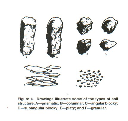
Structure
Soil structure is not judged, however, it is very important
because of its effect upon permeability. It also relates to how well crops
can grow. It is necessary to know about this soil property. Structure means
the shape and arrangement of soil particles into clusters or aggregates.
Each aggregate has a particular shape or size and determines the type of
soil structure. It is best to observe this property in the soil profile
rather than in the sample box because of the disturbance. The various types
are:
Single grained --- Each soil particle functions as an
individual unit due to the lack of binding material. This structureless
condition is usually found in coarse-textured soils.
Granular and/or subangular blocky --- Granular is sphere-like
or rounded aggregate with no flat surfaces due to contact pressure from
the faces of surrounding aggregates. Subangular blocky is block-like or
tending toward six-faced aggregates having mixed, rounded and flat surfaces
with many rounded vertices or corners.
Blocky --- Block-like or tending toward six-faced aggregates
having flat surfaces with mostly sharp, angular vertices or edges that
are mold casts formed by surrounding aggregates.
Prismatic --- Prism-like or vertically-oriented aggregates
with the vertical axis much greater in length than the horizontal axis.
Flat surfaces or faces are well defined.
Columnar --- Structure is a modified type of prismatic
aggregate but with rounded surfaces. It usually suggests salty conditions.
Platy --- Plate-like or relatively thin horizontal plates
or leaflets.
Massive --- Indistinct or no apparent aggregation. This
type is characteristic of clayey, very slowly permeable soils.
| Structure means the shape and arrangement of soil particles into cluster
or aggregates. Each aggregate has a particular shape or size and determines
the type of soil structure. |
Next Page |